Elevating Resilience: Multi-Layered Infrastructures Engaging the Rising Tides
Location: Miami, Florida
Terms: Fall 2019 - Spring 2020
Courses: Design As Research ARCH 9300 - Thesis Studio ARCH 9500
Faculty: Lora Kim - Robert Cowherd

Introduction
Due to the historical evolution of rising sea levels, this thesis explores resilient elevated infrastructure in multiple layers with the highest density development occurring at the waterfront where the most demanding defenses are needed.
Sea levels have been rising dating back as early as 1900, as the number of notified tide gauges along the shorelines of cities has intensified to the modern day, due to the rise of CO2 levels entering the earth’s atmosphere. If the trend continues, coastal cities are at risk of facing social and economic crises.


Site Selection
The site resides in the city of Miami. Of all the cities at the greatest risk of rising sea levels, Miami is ranked number one in North America and number five globally. Despite this, Miami is expected to grow dramatically, both socially and economically, in the coming decades with an emphasis on high-rise residential development unlike any other American city.


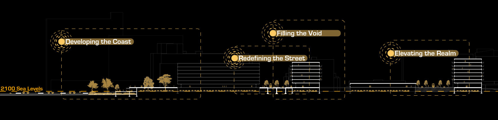
Like the historic dikes of Holland, the coastal defense system for Miami is only as secure as its weakest link. Continuity is dependent on a flexibility of tactics to address the full range of diverse conditions along the coastline. Rather than attempting to customize approaches for every segment of the Miami coast, the conditions of Downtown, South Beach, and West Side serve as the most representative sites covering a majority of the conditions to be addressed. By identifying three representative conditions, the work aims to create a layering of defense strategies to generate a model for a continuous defensive barrier with no breaks. These conditions are selected primarily by the magnitude of density along the shorelines, the differentiation of the urban fabrics, and the degree of vulnerability that exists along the shorelines based on the overlay of future flood data.

South Beach Proposal
The proposal for South Beach starts on the water creating a natural living breakwater designed to be the first line of defense and break the pressure of waves that are generated from storms. By re-purposing the existing green corridor and engaging the street edge with a multipurpose dike, the bulk of the defense comes within these two sectors that transform the beachfront into a major pedestrian hub. Ocean Drive, the closest street to the waterfront, is transformed to create a pedestrian friendly street typology.
In order to become a secondary defense strategy, existing building infrastructure running parallel to Ocean Drive is modified to accommodate parking that can act as a basin. With the high density of layered strategies occurring along the beachfront, the inner city becomes protected and needs minimal adaptation.


West Side Proposal
Like South Beach, West Side targets the water, creating floating docks at the first layer to increase water transit with an elevated baywalk beyond. This creates a continuous pedestrian path along the coast while being the main defense mechanism.
West Avenue and Alton Road, the closest parallel streets to the coastline, are elevated, allowing for the redevelopment of a new street typology to these neighborhoods that eliminates the high density vehicular circulation. Elevating the streets creates a new ground floor datum, requiring the modification of the existing building infrastructures within these blocks.
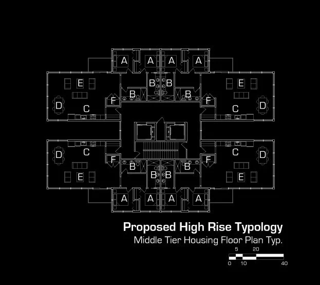
The design of a new architectural typology fills the gaps within these neighborhoods allowing these residents to live with the water, while keeping all the infrastructure safe from flooding. By emphasizing all the defense layers at the blocks closest to the shoreline, the inner city becomes protected and needs minimal adaptation.


Downtown Proposal
Like the previous conditions, the proposal for Downtown starts on the water, creating a new floating architectural typology that becomes the primary defense mechanism along the waterfront. This defense mechanism increases pedestrian activity and water travel.
By modifying the existing green corridors, the parks adapt to the existing elevation change of the building infrastructure becoming secondary defense layers. The goal is to allow the elevation change to occur to defend long term flood levels while avoiding any changes to the existing structures. This forms a connection to a proposed block and transportation center, that have the opportunity to be major pedestrian hubs.
With the dense layering of defense strategies along the shoreline, the need for adapting inland infrastructure is minimal.